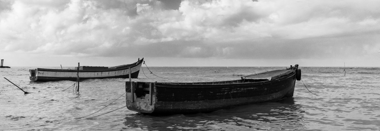
A photo taken from a moving vehicle of a tree standing against the mountain backdrop.
Nothing special, just that I liked it 🙂

Homeward Bound 16-1649 | Canon EOS 6D, Canon 24-105L | 2016
Click on the image to see it in the Black and White Gallery
Photography; I shoot what I like, and sometimes people like what I shoot. All photos are copyright to Michael C. Lam unless explicitly stated otherwise.
A photo taken from a moving vehicle of a tree standing against the mountain backdrop.
Nothing special, just that I liked it 🙂
Homeward Bound 16-1649 | Canon EOS 6D, Canon 24-105L | 2016
Click on the image to see it in the Black and White Gallery
I had just finished up some work, and simultaneously finished up my processing on a photo I took in the Pakaraima’s earlier this year, and I was heading into my vehicle to head home when I was approached by a man of Amerindian descent (our indigenous people).
He called me by my last name, and inquired if I was indeed Mr. Lam, the one who took photographs, once I replied in the affirmative, he proceeded to ask if I had a brother named Patrick, again, I said yes, he apparently went to school with my brother at some point. He then told me how much he enjoyed my photos, I was somewhat stunned to be thus approached on the road, but I was also thrilled. It seems he is now embarking on his own photographic journey.
I would probably never have had the courage to do what he did, but I realise now that I have left many things unsaid to many people simply because I was unsure of how they would take my approaching them gushing about how much I like their work. Judging from my own reaction, I regret not saying to those people whose work I admire, that I love their work, and that they inspire me.
On to the photography – I don’t think I’ve ever treated one of my “safari”or photos taken in the Rupununi or the Pakaraimas in a similar manner to that which I do my seascapes and coastal photos, but something about this one steered me in that direction (yes, the clouds, I know) 🙂

Karasabai, Pakaraima Mountains, Upper Takutu – Upper Essequibo Region, Guyana
Click on the photo to see it in the Gallery.
Since I started using WordPress for this blog, other than using the online interface to write, I’ve been using Windows Live Writer as my main off-line way of drafting and preparing my blog-posts, I had heard sometime back that MS was not developing it further (although its pretty great as it is), this one I tried using Open Live Writer, which is so identical to MS Live-Writer that I forgot I was using a different software. So far, I like it!
The physical structure that believers gather within to offer thanks and praise to a higher being, their God, is often referred to as a church, temple, masjid, mandir, among many other names; but to me this is simply a shelter over the heads of those gathering; growing up as a Roman Catholic we are taught that the church is the people, yet we all refer to the building as the church 🙂
At 58 Mile, Mabura, along the Lethem trail there’s a church building that I almost always photograph in passing, I’ve meant to walk over on more than one occasion, but never did. I don’t know which Christian denomination it belongs to, but seeing a quaint little church against the backdrop of the forest usually makes me think if we were seeking a “place” to gather and worship, maybe out in the open among God’s creation is where it can be every once in a while, to remind us of the wonders of this home we call earth and the God who we believe created it and us.

Church at 58 Mile, Mabura. | Canon EOS 6D, Canon EF 24-105mm L
Another church that has caught my eye a few times as we travel through the Pakaraima mountains is the RC Church of St Francis of Assisi at Rukumuta village in the Pakaraima Mountains. I have photographed it a few times but never caught the essence of it, I think this time I may have done it justice, although I excluded the building entirely (it’s to the right of the end of the frame of the photograph) I think that the idea of a church sitting here, feels right.

St Francis of Assisi RC Church, Rukumuta, Pakaraims Mountains, Guyana.
Canon EOS 60D, Sigma 10-20mm
I’ve often heard people complain about how the missionaries to the third world forced people to convert to Christianity, and while the idea certainly doesn’t sit well with me, the Amerindian people whom I have met, who are Christian never said anything about it, they don’t seem to dwell upon it like some westerners seem to, but I am sure that if the old beliefs are still there in some villages, I do hope that someone is keeping them up and recording them.
This reminded me of something I read last Sunday, about Saint Casilda. According to legend, around the end of the first millennium, she was the daughter of a Muslim King, despite the conflict between Christians and Muslims she showed great kindness to the Christian prisoners. She reportedly was cured of an illness while still a young woman by the healing waters from the shrine of San Vicente, and converted to Christianity soon after.
As I see it, she simply changed her method of worship, not her way of living nor the God she worshiped. Is it possible for us to be open-minded about the existence of God, and the possibility that no matter what we call him/her, no matter what methods we use to praise God, that we can all be one people, that anyone showing kindness to another can be acknowledged for it and accepted as a fellow human being?
Click on the images to see them in the Collection along with other images in the Sepia Gallery.
On the way back from Orinduik, the journey usually takes a slightly different path, we bypass some places, particularly Monkey Mountain, and this cuts short the return trip significantly.
As we awoke at Kurukubaru, we noticed that since the previous evening we could feel a soft drizzle and this had not changed, it was then that we were told that it wasn’t really a drizzle, we were simply in a cloud 🙂

The view from so high up is so breath-taking, that it is hard to render that on camera, one direction looks very much like the other, but you can’t help but snap a few anyway 🙂
 |
 |
 |
Be caught up with the main convoy at Kato and continued our journey onward, here are some more photos from the trail…
 |
 |
 |
 |
 |
 |
 |
 |
We stayed at Yarong Paru where I got in some more photos to show 🙂
 |
 |
 |
 |
I even got one at a village further on, I think it was Tiperu, when Frank and a few others took a break and sat aside the trail 🙂

At Karasabai the Safari was pretty much over, at this point the option was given to members to either head back to town or proceed to Lethem for the Annual Rodeo. We opted for town and overnighted at The Oasis at Annai

As we were crossing the Essequibo River at Kurupukari I noticed Jason washing down his tires from all the mud… presumably making room for more mud as we hit the trail on the other side 🙂

On the other side of the crossing we stopped for Lunch and I took a few moments to get in a couple of shots at the shop 🙂

If I ever make the trip again, I hope I get to spend more time at some of these villages. Click on the images to see them larger in the Gallery along with all the other select images from the Safari!
As we were behind schedule, I thought we would have left Paramakatoi extra early, but we started out close to 8am and headed for Kato.

At Kato we had a brief stop, some vehicles were attended to, and some thirst needs were also attended to 🙂
 |
 |
Our next stop would be at Kurukubaru, although I did not take many photos on the way into the village or even at the village, this one of a family at their home I liked.


From Kurukubaru, our next stop would be the destination of the entire Safari, Orinduik Falls, the route there proved to be unusually treacherous for the vehicles, it was on the way there and back to Kurukubaru that evening that the vehicle suffered the most damage 🙂 Unfortunately, no photos, not a lot of stopping on that leg of the journey 🙂
Just to prove that the Destination was worth it, I’ve selected quite a few photos to show you of Orinduik.

 |
|
|
 |


 |
 |

Although we wanted to make it back to Kato that evening, we lost the main convoy in the rains up at Kurukubaru, and were advised by the villagers not to descend the mountain in the rain, so we spent the night at Kurukubaru, the highest village in Guyana.
There may be one more post in this series, but it will be sometime next week, the Easter Weekend is upon us 🙂
Please click on the photos to see them larger in the Gallery.
Monkey Mountain: We started the day as per normal, early 🙂
I even managed to get in a few snaps before departing, which is a lot more than I managed in 2009.
|
|
|
Our next stop would be in Tuseneng, below you can see some of the terrain that we traversed on the way there 🙂
 |
 |
 |
At Tuseneng, I was fascinated by the “tools of the trade” that could be seen outside the huts / buildings around the village centre.

 |
 |
After Tuseneng we’d be headed towards Paramakatoi passing through Bamboo Creek on the way, this segment of the drive proved more challenging than originally expected as you can see from the photos below:
 |
 |
 |

 |
 |
 |

 |
 |

By the time we arrived at Paramakatoi it was nigh on twilight, and Frank sought permission for us to stay there for the nigh, even though our original destination for the day would have been Kato.

Click on the images to see them larger in the Gallery, especially the trail ones 🙂
One of the stops on the mini Jamaican Safari that Cecil Beharry took my cousin Alex and myself on was the Cinchona Gardens. As captivating as the old Gardens itself was, the first thing, and the last thing, that we looked out upon was the view from the mountainside, down into the St Andrew parish.
Although I can try with every possible photographic tool at my disposal to convey to others the emotion that I felt standing there, I don’t think I can ever truly do it justice.
As we stepped out of the vehicle, we were greeted with a clean, cool mountain air that revived the senses and the spirit, after that long arduous drive, I’m sure that Cecil was the most grateful of us for that.
The view was breath-taking, the clouds and mists had claimed the tops of the mountains leaving just the valley for the viewer. From the flowers dotting the edge of the road where the steep descent began, the valley spread out and rose and fell to the distant mountain peaks, from our vantage point, the mountain-sides that envelope and nestle the Cinchona Gardens framed the scene beautifully.
This is a view of an Island Paradise… from 5,200 feet up.

This is a Panoramic Photograph from thirteen images (each taken in portrait orientation) stitched together. Click on the image to see it in the Gallery
The thirteenth week of this year found me on the road trail, heading into the Pakaraima mountains towards Orinduik Falls on the Ireng River that borders Guyana and Brazil.
Although I took quite a few photographs, I had not been able to fully go through and process them, this week I did manage to do some narrowing down.
I have lots of photos of mountains and vehicles from the trip, not too many people, but I decided to go against the flow and choose one of a person…
When I took this photo I noticed the “look” in the eyes, Naseem had that Clint Eastwood stare, and with the hat and the general scene I was reminded of the spaghetti westerns.
Its not a Spaghetti Western, maybe we can call it a Macaroni Western, starring The Great N, and we’ll title it “A Neckful of Straps” 🙂 And the catchphrase could be “Mister, I’m watching you, one of these straps has your name on it.” 🙂

Although I was tempted to try for a “Technicolor” processing, I went for a copper-tone instead 🙂 As always, please click on the image to get a better view in the Gallery.
There’s a place called Kato, that has a Waterfall that’s very beautiful to a traveller, I was so enthralled and excited that I have to admit to taking very lousy photographs of it.
In this photo you can see some of the travellers enjoying the refreshing waters of the falls, this is a short drop, there was a larger one not too far off (not too large though 🙂 )

The mighty Kaieteur, the largest single drop waterfall (by volume) in the world. Let’s not get confused, it’s NOT the tallest single drop waterfall in the world, but when you’re comparing the sheer volume of water flowing over it, it is the largest single drop waterfall in the world, make note of that distinction. It has a single drop of 226 meters (741 feet), and averages about 663 cubic meters of water per second (23,400 cubic feet per second). It is awesome!
For you Canadians and Americans, it’s about five times the height of Niagara,
You can read more about the falls and its history on other sites, I’m not about to go regurgitating all that data here 🙂
For years I’ve always avoided flying into Kaieteur because I could always say that my money would be better spent (in terms of distance and longevity) in going to one of the Caribbean Islands, it was cheaper to go to Trinidad (and stay for a week or two) than to go to Kaieteur and spend two hours.
My first visit to Kaieteur was in 2009, and if I could give up my day-job and become a guide for a tour company just so I could see Kaieteur every week, I’d do it, but then again, I like my job 🙂
This photo was resurrected from my files recently, I had taken three exposures for an HDR, and I decided to re-process those files and see what happens. It won’t be great (especially to enlarge it), it was taken with the Canon PowerShot S5 IS bridge camera with a Raynox 0.66x wide angle adapter attached, You can probably see some of the lens distortion at the edges.
This is my favourite view of Kaieteur (other than the views from the airplane, of course) This is known as Johnson’s View, it’s the furthest view from the falls and gives a beautiful view on the vista.

Definitely, click on the image here to see it better in the gallery.


